 by
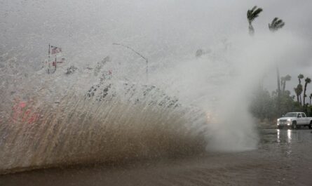
by Phoenix, Arizona – If monsoon moisture continues to move into the Valley, there is a possibility that morning storms will disrupt the commute in Phoenix on Tuesday, July 22nd. Before eleven o’clock in the morning, there is a thirty percent probability that showers and thunderstorms will develop. These storms will bring with them slick roads, brief gusty gusts, and localised street flooding in low-lying regions.
Following the clearing of the early precipitation chances, the National Weather Service in Phoenix forecasts that the city will reach a maximum temperature of 98 degrees Fahrenheit on Tuesday. At approximately five miles per hour, winds will change from the east, and by late afternoon, drier air will begin to settle in. It is imperative that motorists remain vigilant on Interstate 10 and Loop 202 throughout the morning hours, particularly during any pop-up cells that may occur.
The sky will be largely clear on Tuesday night, and the temperature will drop to around 81 degrees Fahrenheit. Midweek will see the buildup of high pressure, which will bring the temperature in Phoenix back up to triple digits. Under clear skies, temperatures will reach 102 degrees Fahrenheit on Wednesday and 105 degrees Fahrenheit on Thursday. Winds will be calm to light each afternoon.
Extended Five-Day Outlook:
- Tuesday, July 22: 30% chance of morning storms. High 98°F / Low 81°F.
- Wednesday, July 23: Sunny and dry. High 102°F / Low 80°F.
- Thursday, July 24: Mostly sunny. High 105°F / Low 80°F.
- Friday, July 25: High near 106°F. Calm morning, breezy afternoon.
- Saturday, July 26: Sunny and hotter. High near 109°F / Low 81°F.