 by
by Savannah, GA – Heavy rainfall continues to batter parts of the Southeast, particularly North Carolina and South Carolina, where flash flooding has already claimed two lives and prompted widespread weather alerts.
Tragedy Strikes in Nash County
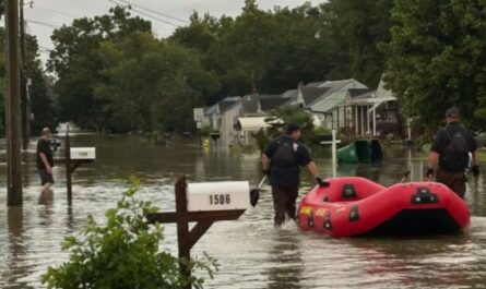
The most devastating consequence of the ongoing flooding occurred in Nash County, North Carolina, just outside Raleigh, where a man and a woman were swept away by floodwaters after their vehicle plunged into a ravine. Authorities said the pair managed to climb onto the roof of their car, but rising water ultimately carried them off.
Their bodies were recovered after an intensive search by emergency personnel.
“During these storms, it takes up just a little bit of debris in these pipes and things of nature that are going under the roads to turn a low area into a flooded area,” said Nash County Sheriff Keith Stone. “I caution you when you’re driving at night, when you go into these low-lying areas, that it is acceptable to flood you.”
Widespread Weather Alerts and Ongoing Risks
A stalled frontal boundary across the Southeast is fueling persistent downpours from Interstate 10 through Georgia into the Carolinas. Forecast models suggest some areas could receive double-digit rainfall totals through the weekend.
According to Fox Weather, flood watches remain in place for numerous counties, particularly in regions already saturated by recent rainfall. Meteorologists warn that these watches could quickly escalate into Flood Warnings if training storms—where thunderstorms repeatedly move over the same area—develop.
Communities most at risk include:
- Charleston, SC
- Myrtle Beach, SC
- Wilmington, NC
Tropical Development Being Monitored
Adding to concerns is a tropical disturbance off the western Atlantic, which the National Hurricane Center is monitoring closely. While the system remains disorganized, forecasters have given it a low chance of development into a tropical depression or tropical storm over the next few days.
A Hurricane Hunter aircraft has been placed on standby should further investigation be required.
Although rapid development is not currently expected, meteorologists are watching the system for any signs of increasing strength.
Coastal and Severe Weather Threats Continue
Beyond flooding, the region faces risks of isolated severe thunderstorms, which could bring:
- Damaging wind gusts
- Frequent lightning
- Localized flash flooding
These storms are expected to move slowly, increasing the likelihood of heavy rainfall accumulation over localized areas.
Even without a fully formed tropical storm, coastal communities from Florida to the Carolinas are being warned of rough surf, strong rip currents, and dangerous swimming conditions.
Read Also: Hazy Skies and Poor Air Quality Blanket San Diego as Wildfire Smoke Lingers
Cooler Temperatures Amid the Storms
One surprising consequence of the persistent cloud cover and rain has been a drop in daytime temperatures. Several observation sites across the Southeast reported near-record-low highs, with some locations struggling to climb out of the 70s—well below the average for August, the final month of meteorological summer.
Stay Alert and Prepared
With rainfall expected to continue for several more days, residents and travelers in the Southeast are urged to:
- Avoid driving through flooded roads
- Monitor local weather alerts
- Prepare for potential power outages
- Be cautious at coastal areas and beaches
Have you been affected by this week’s storms or flooding in the Carolinas? Share your experience or photos with us at ibwhsmag.com and help others stay informed during this ongoing weather emergency.