 by
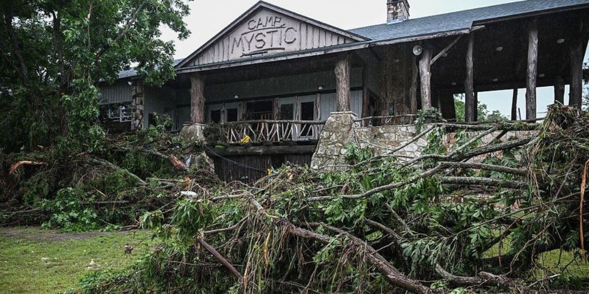
by The Texas summer camp where dozens of girls died in July 4th flash flooding is located in the middle of a well-studied, high-risk flood zone, according to mapping data from the Federal Emergency Management Agency.
At least 27 campers and counselors at Camp Mystic perished in Friday’s floods, with the total death toll across the surrounding part of Central Texas now surpassing 100, according to local officials.
Established 99 years ago, Camp Mystic was built on the banks of the Guadalupe River, which reached catastrophic levels in the early hours of Friday morning, rising some 26 feet in 45 minutes after torrential rain in the area, well known to be prone to flash flooding.
Data from FEMA’s National Flood Hazard Layer Viewer shows that much of the camp, including many of the cabins where children slept, is located squarely inside Zone AE, a designation that indicates a 1% annual chance of flooding.
Some of the cabins were located in the floodway, the main channel for floodwaters in a 100-year event, where residential construction is typically heavily restricted if not outright banned. FEMA data shows that the area was last mapped for flood risk in 2011.FEMA’s flood-zone mapping shows that the area of Camp Mystic had been well-studied for flood risk. Some cabins are located in the 100-year flood risk zone (blue) as well as the floodway (striped), the main channel for 100-year floods where building is usually heavily restricted.
Due to the age of the camp, cabins in the flood-risk zone were likely constructed well before the detailed studies that identified the boundaries of the flood zone, says David Givler, a civil engineer and hydrologist, and president of Givler Engineering in San Antonio.
“A lot of these older areas will have structures that get grandfathered in, because they existed before the regulations came into play,” Givler tells Realtor.com. “But the water doesn’t care.”
A spokesperson for Camp Mystic did not respond to a request for comment on Monday afternoon. A statement on the camp’s website read in part: “Our hearts are broken alongside our families that are enduring this unimaginable tragedy. We are praying for them constantly.”
At the time of the flood, there were roughly 750 girls between the ages of 7 and 17 staying at Camp Mystic, with the green-roofed cabins in the high-risk floodway believed to be hosting some of the junior campers.
The girls camp, known for its popularity among the daughters of Texas’ political elite, is located in Kerr County, a sparsely populated rural region in the hills northwest of San Antonio that is home to numerous children’s summer camps.
The area is also well known for its flood risks, due to its steep terrain, rocky soil, and the common occurrence of sudden, torrential rainstorms.
“We have floods all the time. This is the most dangerous river valley in the United States, and we deal with floods on a regular basis,” Kerr County Judge Rob Kelly said at a news conference after Friday’s disaster. But “we had no reason to believe that this was going to be anything like what’s happened.”
According to Givler, some rain gauges in the affected area registered downpours that met the local definition of 100-year rainfall event, while others exceeded that threshold and registered precipitation between 500- and 1,000-year events.
The extent of local flooding in any particular area would depend upon the average rainfall across the watershed, and also how long it took for water to flow downstream to any particular point, he notes.
“But it’s clear that there was some extreme rainfall going on,” he says. “So I wouldn’t be surprised if much of the flood exceeded the 100-year condition.”Search and recovery workers dig through debris looking for any survivors or remains of people swept up in the flash flooding near Camp Mystic on July 6, 2025, in Hunt, TX.
Flood risks widespread for Texas homes
A recent study from the Neptune Flood Research Group estimated that Texas has 2.1 million properties projected to face flood exposure over the next 30 years, with over 200,000 expected to flood with “near certainty.”
Texas already ranks second nationally in flood insurance claims through the National Flood Insurance Program, with over 150,000 claims and $11.6 billion paid over the past decade.
Yet only 7% of residential properties statewide have flood insurance, and more than half of flood claims since 2005 were for properties outside of FEMA-designated high-risk flood zones where mortgage lenders require flood insurance, suggesting more widespread exposure than previously realized.
“Texas faces a clear and growing flood risk, yet millions of properties remain without adequate insurance coverage,” according to Neptune President Matt Duffy. “As flood risk continues to rise due to climate change and development patterns, and with an active 2025 hurricane season on the horizon, addressing these gaps remains a critical priority for homeowners, insurers, and policymakers alike.”
Neptune’s report called on Texas officials to go beyond the risk-mapping tools available from FEMA and adopt “forward-looking, data-driven risk models to identify vulnerable communities better and guide zoning, insurance, and development decisions.”
Friday’s deadly flooding in Kerr County highlights the need for better risk assessments and preparation strategies, says Realtor.com senior data research analyst Hannah Jones.
“The July 2025 flash floods have had immediate and likely lasting effects on central Texas’s real estate landscape, underscoring the need for adaptive strategies in the face of increasing climate-related risks,” she says.
However, in rural areas such as Kerr County, which are sparsely populated and have a limited tax base, the public support for costly new flood-risk studies can be limited, notes the hydrologist Givler.
“It takes longer to get all this detailed work in the unincorporated areas” like the location of Camp Mystic, he says. “In this case, there actually was a detailed study, but I suspect—and I don’t know for sure—but I suspect that the buildings were probably there before the detailed study came out.”
Early alert systems now under scrutiny
Camp Mystic was at a particular disadvantage due to its location near the headwaters of the Guadalupe, reducing the warning period for evacuation.
The tragedy has already raised questions about whether more could have been done to raise the alarm and prompt evacuations.
The National Weather Service, which had previously issued a flash flood watch for the area, issued a flash flood warning at 1:14 a.m. on Friday, triggering cell phone alerts urgently warning of life-threatening danger. However, the rural area is known for spotty cell service, and Camp Mystic did not allow campers to keep cell phones in their cabins.
By 4 a.m., devastating floodwaters filled with floating debris were already ripping through Camp Mystic, sending campers and counselors fleeing for their lives.
According to KXAN, county officials didn’t issue warnings until four hours after the NWS alerts, at 5 a.m. and 7 a.m. By that time, the floodwaters had already claimed scores of lives.
Texas Gov. Greg Abbott has said that an upcoming special legislative session will focus on how to improve flood warning systems for future disasters.