 by
by Lake County, FL – Central Florida’s Lake County was inundated by an extraordinary 19 inches of rain in just a few hours on Sunday night, prompting the National Weather Service to issue a rare Flash Flood Emergency. The severe rainfall led to widespread flooding, swamping cars and closing roads across the region.
This unprecedented downpour has left local communities grappling with significant flooding challenges, though fortunately, no injuries have been reported as of Monday morning.
Unprecedented Rainfall Triggers Emergency Response
On Sunday night, intense thunderstorms swept through the Gulf Coast and Central Florida, unleashing torrential rains on Lake County. The National Weather Service Office in Melbourne responded quickly by issuing a Flash Flood Emergency — a rare and serious warning reserved for life-threatening flooding situations.
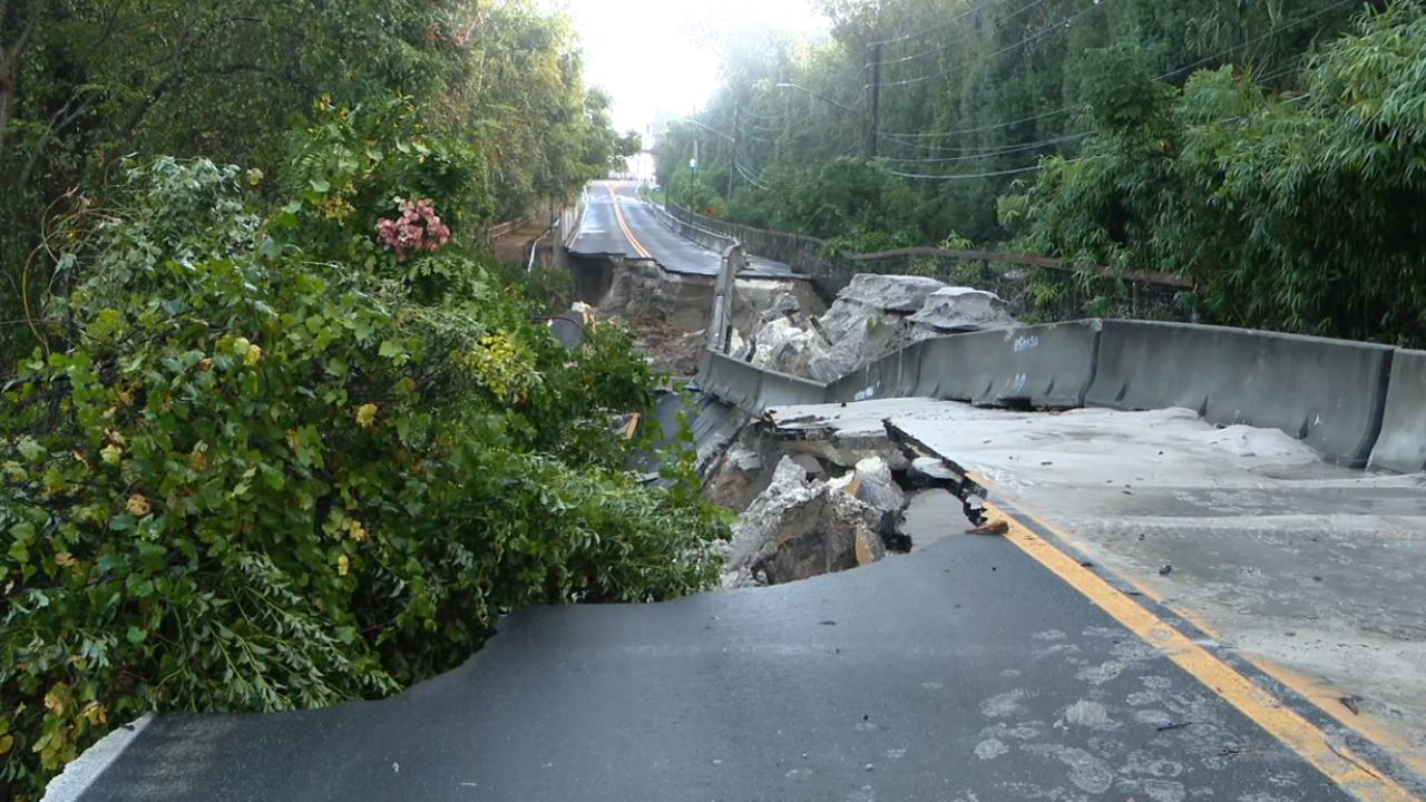
The rainfall total exceeded 19 inches within a few hours, causing severe inundation that persisted into the early morning hours of Monday. Key transportation routes were severely impacted. For example, images from the Florida Department of Transportation showed State Route 46 near Sanford completely submerged even after sunrise.
- Multiple road closures were reported, including near downtown Eustis, Mount Dora, and Titusville.
- The Lake County Sheriff’s Department noted that two sinkholes appeared Sunday night near a roadway in Eustis, adding to the hazard.
- Despite the flooding, Lake County schools remained open and operated normally.
Storm Origins and Ongoing Weather Threat
The flooding was caused by a potent area of low pressure in the upper atmosphere, which had earlier caused major storms in Texas on Saturday that knocked out power to hundreds of thousands. This system moved across the Gulf Coast Sunday night before impacting Central Florida with severe thunderstorms.
Read Also: California’s Climate Rules Challenged: Exxon Files Suit Against SB 253 & SB 261
“This kind of intense rainfall leading to a Flash Flood Emergency is rare and highlights the dangers posed by these fast-moving, heavy storms,” said a meteorologist from the National Weather Service.
Additional rounds of thunderstorms are expected to continue moving through the region Monday afternoon, with a Flood Watch remaining in effect through 8 p.m. Monday for Orlando and parts of east-central Florida from Daytona Beach to north of Vero Beach.
For detailed updates and expert insights, see the full report on Fox Weather.
What Residents Need to Know
- Stay informed: Monitor local weather alerts and heed any warnings or evacuation orders.
- Avoid flooded areas: Roads such as State Route 46 and others are unsafe; do not attempt to drive through floodwaters.
- Be prepared for more storms: The weather system continues to threaten east-central Florida with additional rainfall and flooding.
As the community deals with the aftermath, officials continue to monitor conditions closely to ensure public safety.
What do you think about this extreme weather event and its impacts? Share your thoughts in the comments below!