 by
by Miami, Florida – While Hurricane Erin has stayed well offshore, the storm’s indirect impacts are being felt across the Sunshine State. The cyclone, located about 400 to 600 miles east of Florida, disrupted the region’s typical summer rainfall pattern, leaving behind hot, dry, and windy conditions that are now fueling widespread wildfire concerns.
Hurricane Erin’s Indirect Impacts
Even though the storm posed no direct landfall threat, Erin’s outer circulation pulled drier air into Florida’s atmosphere. Normally, the state depends on daily thunderstorms to balance its climate and reduce fire risks, but with moisture suppressed, wildfires have begun spreading at alarming rates.
Meteorologists warn that this kind of setup is rare but dangerous. Erin’s presence offshore essentially acted as a barrier, preventing tropical moisture from reaching the peninsula.
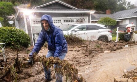
Wildfires Expanding Across South Florida
The most serious blazes are now burning west and northwest of Miami, where officials estimate one brush fire has already destroyed more than 20,000 acres. Smaller fires have also been reported in multiple counties, keeping first responders on high alert.
Persistent northwesterly winds are carrying smoke across major metropolitan areas, worsening air quality for millions of residents. Health officials have issued Air Quality Warnings, noting that “fine particulates concentrations may approach or exceed unhealthy standards” in parts of South Florida.
Drought Conditions Worsen
According to the U.S. Drought Monitor, about 30% of Florida is considered abnormally dry, with some southeastern communities classified under severe drought. Experts are watching for what is known as a “flash drought” – a sudden escalation of dry fuels, high heat, and below-normal rainfall that accelerates wildfire risk.
The lack of rainfall has created a tinderbox effect across Florida’s landscapes. Without daily storms to replenish soil and vegetation moisture, even a small spark can rapidly evolve into a destructive blaze.
Read Also: Southwest Braces for Life-Threatening Heat Wave With Temperatures Soaring Above 110 Degrees
Heat and Smoke Trigger Multiple Alerts
The combination of triple-digit heat indices, smoke-filled skies, and low humidity has led to overlapping weather and health advisories. Alongside Air Quality Warnings, the National Weather Service has issued Heat Advisories for much of South Florida, urging residents to limit outdoor exposure.
In Miami and Fort Lauderdale, the smell of smoke has lingered for days, causing discomfort for sensitive groups such as children, seniors, and those with respiratory issues. Hospitals are already reporting an uptick in asthma-related visits.
Limited Relief on the Horizon
Forecasters say a frontal boundary is expected to stall over the Southeast U.S. and along the Interstate 10 corridor, potentially delivering some beneficial rainfall later in the week. However, the front is unlikely to extend far enough south to provide widespread relief across Florida.
The FOX Forecast Center noted that without consistent thunderstorms or tropical systems, the state may remain in a prolonged dry spell. Ironically, Florida’s best chance for widespread rainfall may come from direct impacts of a tropical cyclone – something that is not in the current extended forecast.
Looking Ahead
For now, Florida residents are being urged to remain vigilant. State officials emphasize the importance of following local burn bans, avoiding outdoor flames, and preparing for possible evacuation orders if wildfires spread further.
With drought conditions expanding and wildfire activity intensifying, experts say this late-summer pattern serves as a reminder of how even distant tropical systems like Erin can have severe consequences for Florida’s environment and public health.
What do you think Florida should do to better prepare for wildfire risks during hurricane season? Share your thoughts in the comments at ibwhsmag.com.