 by
by LA CROSSE, WISCONSIN – A strong cold front pushing into western Wisconsin this weekend is forecast to bring a round of potentially severe storms, with threats including damaging winds, quarter-size hail, and brief periods of heavy rainfall by Saturday evening.
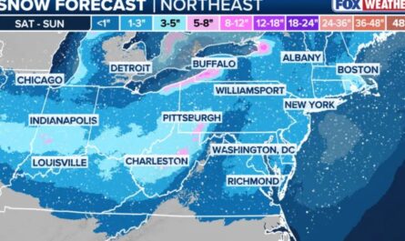
The National Weather Service (NWS) in La Crosse has placed the region under a Level 2 out of 5 risk for severe weather, meaning scattered strong storms are possible. This system is expected to form along the front as it advances through eastern Iowa, southeast Minnesota, and into western and central Wisconsin.
Cities including La Crosse, Eau Claire, Tomah, and Madison lie directly in the risk zone.
What Time Will the Storms Hit?
According to the NWS, storms are forecast to develop late Saturday afternoon and intensify into the evening hours.
The window of concern is from approximately 4 p.m. to midnight, when the cold front’s arrival will interact with daytime heating and unstable air across the region.
“Storms may ignite along and ahead of the front as it crosses the Mississippi River Valley and drifts into Wisconsin,” forecasters said.
Isolated supercells could be possible in the early stages, later evolving into a line of storms that sweeps eastward through the state.
Primary Threats: Damaging Winds and Hail
The most serious concerns involve wind gusts exceeding 60 mph and hail up to 1 inch in diameter, both capable of causing property damage or injuring those caught outside.
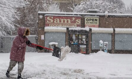
As per the Country Herald, though not the top concern, brief heavy downpours may also accompany these storms, reducing visibility and causing minor flooding in low-lying areas.
The National Weather Service warns that falling trees and flying debris are real risks if storms organize into fast-moving clusters.
Residents with weekend outdoor plans — especially in parks or campgrounds — should remain weather-aware and have shelter options ready.
Safety Tips for Residents
Officials advise residents across the affected regions to prepare ahead of the storms. Here are some key actions:
- Charge mobile devices in advance
- Secure outdoor furniture, tents, or tools
- Have a weather radio, app, or emergency alert system ready
- Know your nearest shelter or interior room in case warnings are issued
Read Also: Deadly Flash Flooding in the Carolinas Leaves 2 Dead, More Rain Expected
Power outages are possible in areas where trees fall or power lines are impacted. Localized damage may also disrupt traffic or delay emergency responses in rural zones.
What Happens After Saturday?
After the initial wave of storms Saturday night, the cold front will continue pushing eastward, and weather conditions are expected to gradually improve by early Sunday morning.
However, meteorologists caution that the exact speed and placement of the front may impact storm strength and timing.
“If instability remains in place or the front stalls, we could see a few more severe storms through early Sunday,” the NWS noted.
Additional watches or warnings could be issued into the weekend depending on how the atmosphere evolves.
Moderate Risk Requires Serious Attention
While a Level 2 (Slight Risk) doesn’t guarantee severe weather, it means conditions are favorable enough that a few strong storms are likely, and some may be intense.
This is especially important for families traveling, outdoor workers, or event organizers planning activities in the region Saturday afternoon or evening.
How are you preparing for this weekend’s storms in Wisconsin? Join the discussion and share safety tips at ibwhsmag.com.