 by
by Memphis, TN – Residents across the Mid-South should brace for a notable change in the weather pattern this week as showers and thunderstorms become increasingly likely ahead of an approaching cold front.
The National Weather Service (NWS) in Memphis forecasts a steady increase in rainfall chances from Monday through Wednesday, with cooler temperatures expected to kick in by Wednesday, September 24, and persist into the weekend, bringing relief from the recent summer-like heat.
Rainfall and Thunderstorm Outlook Midweek
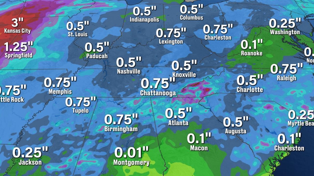
According to the NWS, a significant uptick in rain showers and possible thunderstorms is predicted during the middle of the week, coinciding with the advancement of the cold front through the region. This weather activity is expected to impact several key Mid-South cities, including:
- Memphis
- Clarksdale
- Jackson
- Tupelo
Residents are encouraged to stay updated on daily weather reports to make informed decisions for travel and outdoor plans, especially leading into the weekend.
“Showers and possible thunderstorms are most likely during the midweek period as the front moves through,” advises the National Weather Service in Memphis. “Monitoring daily updates is key for safety and planning.”
Cooling Temperatures Signal a Return to Normal Late-September Weather
The cold front will usher in a notable cooling trend, with high temperatures dropping from the upper 80s and low 90s seen earlier in the week down to the mid-to-upper 70s by Friday and Saturday. Overnight lows will also fall, settling in the upper 50s to lower 60s.
This transition marks a return to close to average late-September temperatures for the region after a prolonged spell of warm weather. For example, in Memphis, the highs are projected to be in the low 80s on Tuesday before cooling into the mid-70s later in the week.
Read Also: Missouri Weather Alert: Heavy Rain and Thunderstorm Threat in Springfield Through Monday
Other areas like Oxford, Corinth, and Union City will see similar trends with both daytime and nighttime temperatures dropping significantly.
- Tuesday highs in Memphis around the low 80s
- By Friday and Saturday, highs cooling to mid-to-upper 70s
- Overnight lows decreasing into the 50s and 60s
- Consistent cooling effects expected across the Mid-South
Preparing for the Week Ahead: What Residents Should Know
With this anticipated weather shift, local authorities and forecasters urge the public to anticipate scattered thunderstorms and plan accordingly:
- Stay informed by checking daily weather updates from official sources.
- Be cautious about travel and outdoor activities during midweek rainfall and storms.
- Expect temperatures to be milder and dress accordingly as the week progresses.
For comprehensive updates and detailed forecasts, residents can visit the full report on the Country Herald Tennessee weather page.
Stay Alert As Weather Shifts Across Tennessee This Week
The combination of thunderstorms followed by a cooler air mass will define the weather story for Tennessee this week, marking a clear shift from summer to autumn. Locals are advised to remain vigilant and prepared to adapt plans in response to changing weather conditions.
What do you think about Tennessee’s upcoming weather changes? Are you prepared for the thunderstorms and cooler temperatures? Share your thoughts in the comments below!