 by
by Miami, FL – Tropical Storm Erin, which continues to move west through the Atlantic, is forecast to become the season’s first hurricane, with predictions of it growing into a major hurricane by the weekend, according to the National Hurricane Center (NHC).
Current Location and Movement
As of the NHC’s 5 a.m. update on Wednesday, Erin was located approximately 1,400 miles east of the northern Leeward Islands in the Caribbean. The storm was moving west at 20 mph with maximum sustained winds of 45 mph. Tropical storm-force winds extend out 60 miles from the storm’s center.
On the forecast track, the center of Erin is expected to move near or just north of the northern Leeward Islands over the weekend. NHC Senior Hurricane Specialist Richard Pasch stated, “Gradual strengthening is forecast to begin today, and Erin will likely become a hurricane by late Thursday or early Friday.”
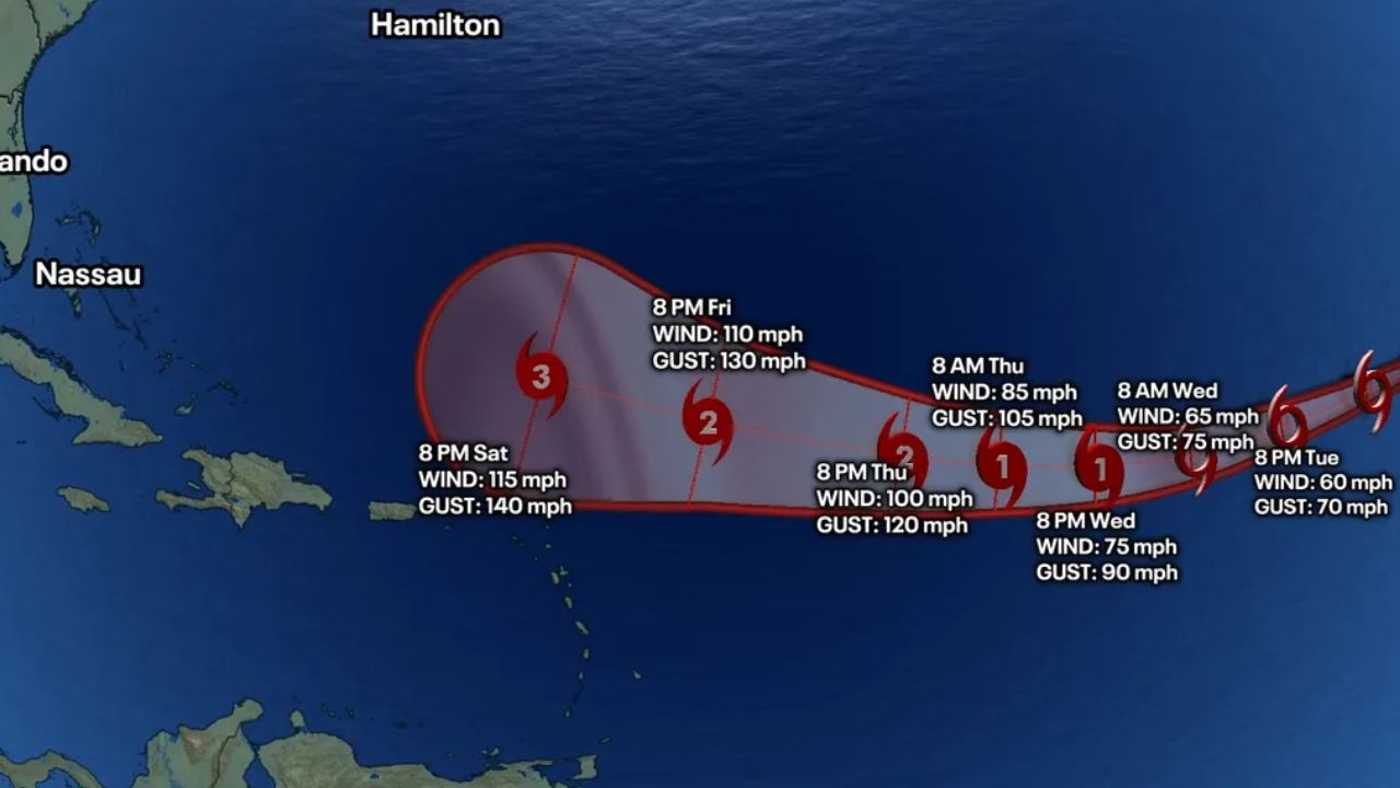
Forecast and Intensity
The cone of uncertainty shifted slightly northward from Tuesday, reducing the likelihood of the storm’s direct impact on the northwest Caribbean islands. However, the storm is expected to intensify over the next 48 hours as conditions improve.
Erin is expected to strengthen into Category 1 hurricane status by Thursday with 75 mph sustained winds. By Sunday morning, forecasters predict it will have developed into a major hurricane, potentially reaching Category 3 with sustained winds of 115 mph and gusts of up to 140 mph.
The storm’s cone of uncertainty now covers a wide swath in the Atlantic, just north of the Leeward Islands, Virgin Islands, and Puerto Rico. The storm could impact the islands by Friday, though the exact magnitude of these impacts remains uncertain.
Impact on Islands and U.S. Territories
The National Hurricane Center emphasized that Erin may move close enough to the northern Leeward Islands, Virgin Islands, and Puerto Rico over the weekend to produce some impacts. “However, the magnitude of those impacts is still not known, and interests there should continue to monitor the progress of this storm,” the NHC said.
Although the direct impacts on the U.S., Bahamas, and Bermuda remain uncertain, the NHC continues to advise preparedness and close monitoring.
Additional Atlantic Systems
According to Orlando Sentinel report, As of 2 a.m., the NHC was also tracking another Atlantic system and a potential Gulf system that may develop once it emerges from the Yucatan Peninsula on Thursday.
- Atlantic System: A nontropical area of low pressure, located a few hundred miles southeast of Nova Scotia, Canada, is producing disorganized showers and thunderstorms. Forecasters have given it a 10% chance to develop into a tropical system over the next seven days.
- Gulf System: A tropical wave over the northwestern Caribbean Sea is producing disorganized showers and thunderstorms extending across eastern Honduras, northeastern Nicaragua, and adjacent marine areas. This system is forecast to move west-northwestward across the Yucatan Peninsula on Wednesday, with a 20% chance of developing within seven days.
Hurricane Season Outlook
The National Oceanic and Atmospheric Administration (NOAA) has updated its forecast for the 2025 Atlantic hurricane season, calling for 13-18 named storms, of which 5 to 9 could become hurricanes. Of these, 2 to 5 could develop into major hurricanes (Category 3 or higher). The peak of hurricane season typically occurs from mid-August to October, with the season running from June 1 to November 30.
While Tropical Storm Erin continues to develop, the National Hurricane Center is urging those in its potential path, especially those in the Leeward Islands and Puerto Rico, to stay vigilant and monitor the storm closely. As the system strengthens over the coming days, residents and officials should remain prepared for possible impacts, especially if the storm intensifies as forecast.
For more updates, keep following ibwhsmag.com.
Have thoughts on how this storm might affect you? Leave your comments below and share your preparations for hurricane season.